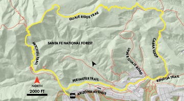
Guaje Ridge dominates the northern skyline of Los Alamos. Combined with the Perimeter and other trails, the ridge offers one of the premier trips in the area, a long but rewarding loop through the Cerro Grande burn scar. The loop uses the Mitchell Trail to gain 1,500 feet in the first 2.5 miles, and then gradually loses that elevation along 3.5 miles of Guaje Ridge. Almost the entire route is in the Cerro Grande burn scar, and some of it was reburned by the Las Conchas fire.
Length: 10.5 miles
Elevation Gain: 1,800 feet
Fitness Level: Difficult
Features: 360-degree views
Trail Surface: Packed dirt
Field Notes: Recommended foot traffic only
Head up the Mitchell Trail. The first section is a gentle climb along a low ridge. In one mile the trail crosses Rendija Canyon and ascends steeply to the first saddle. The climb isn’t over here, as Guaje Ridge, hidden until now, is still ahead. Gain another 400 feet over the next half-mile to reach the ridge. Near a plaque honoring trail builder David Mitchell, turn right onto the Guaje Ridge Trail. Most of the next three miles offer stunning views in all directions.
Reach the Upper Guaje Road (Forest Trail 802) about 6 miles from the start. Turn left and head down the steep road for a quarter mile. At a small saddle, turn right onto the unmarked Cabra Loop Trail. Wind over mesas and through canyons to meet the Rendija Trail in the bottom of Rendija Canyon. Bear right and in a few minutes continue straight to head through the Rendija Crack. On the west side of the crack, stay in the canyon bottom. In a tenth mile, bear left out of the canyon bottom and reach Forest Trail 802. Turn left onto the road and then pick up the Perimeter Trail on the right. Follow this trail 2 miles to the Mitchell Trail, and turn left to return to the trailhead.
