Vistas and Viewpoints

Vista & Views.jpg

The natural vistas of the landscape of Los Alamos County form the backdrop of daily life within the community. The views offered by the surrounding canyons, mesas, and mountains are an integral part of residents views from living rooms or offices, their daily commute, and their visits to open places. Often taken for granted, but for many residents the scenery around the community is a positive, constantly uplifting part of life in Los Alamos. Vistas are land areas that are delineated by geographic features. Key vistas are areas of a significant scenic quality that are visible by a large number of residents and visitors from adantageous viewpoints.

The proposed Open Space Management Plan seeks to retain Los Alamos' special character of open and scenic vistas across a natural and memorable landscape; opportunities for solitude, inspiration and renewal.

Significant Vistas:

Anderson Overlook

Anderson Overlook

This unique roadside viewpoint provides the majority of visitors to Los Alamos a first impression of the scenic beauty of the landscape. At a wide turn in the road, a parking area provides motorists an opportunity to safely park and to leisurely enjoy the view. It is not unusual for visitors to stop, study the view, and to document their stop and the Los Alamos scenery with photographs.

Anderson Overlook is located on a cliff band at about mid-section of the buff and orange Bandelier tuff near the tip of the southern arm of Los Alamos Mesa. The point of the mesa about 100 feet above is called Meditation Point. The viewpoint lies on the east wall of Pueblo Canyon and its vista is off to the north and east. The foreground is comprised of lower Pueblo Canyon. The bottom of the canyon is relatively flat, with the green thread of the Pueblo Canyon wetlands visible in the middle distance. The interior of the canyon is dominated by juniper savannah, and tall, well-watered ponderosa pines line the channel banks in many locations. The gently rolling hills add shadows and textures to the scene.

However, the dominate feature of the vista is the orange cliffs of Bandelier tuff. The rock walls rise for up to 500 feet walls from the canyon bottom. The colors of the rocks are pastels: buff, tan, pale orange, and white. The colors are mixed in layers on the rock faces. The gradation of colors delineates various eruptions of the Valles Caldera to the west.

Sierra de los Valles

Sierra de los Valles

The Sierra de los Valles vista is the backdrop to Los Alamos. It is the defining landscape scene from the downtown area east to the County boundary. Named for their location bordering the high valleys of the Jemez Mountains, the Sierra de los Valles form the east rim of the Valles Caldera. The range is comprised of superimposed volcanic domes that predate the caldera-forming eruptions about 1 million years ago.

Prominent summits visible from many locations are Tsichoma Peak, Caballo Mountain, Cerro Rubio, and Pajarito Mountain. The highest peaks stand above 10,400 feet. The deep gashes of Rendija, Pueblo, and Los Alamos canyons add topographic interest to the scene. The wrinkled ridges, towering domes, and jagged rock outcrops of the sierra spread from north to south. Together, they create an easily recognizable skyline that stand in sharp contrast to the deep blue sky. Viewed as a whole, it is possible to mentally reconstruct the dome of the Jemez volcano.

Lower Canyons

Lower Canyons panorama

In the late 1960s, the Atomic Energy Commission disposed many of its land holdings within the community of Los Alamos. Two significant parcels to the east of the townsite were deeded to the County with the restriction that they be maintained for recreational use.

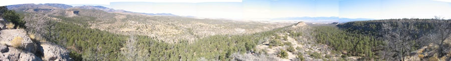
Thus, Deer Trap and Kwage mesas essentially became the first Los Alamos County Open Space. Both mesas extend for more than a mile east, from the end of the streets of Barranca and North mesas. Deer Trap Mesa has three fingers that end in viewpoints; Kwage Mesa has a single point that offers long-distance views. Each of the mesa tips are viewpoints for the Lower Canyons vista. Encompassed in the vista is lower Pueblo, Bayo, Barrancas, and Rendija canyons.

The mesa points sit on the upper layers of the Bandelier tuff, and each overlook the surrounding canyons. The elevation change from rim to canyon bottom ranges from 400 to 600 feet. The canyon bottoms hold a mix of juniper savannah and ponderosa pines stands. South-facing slopes are dotted with thin stands of piñon, juniper, and an occasional ponderosa pine. The north-facing slopes hold ponderosa pine stands with some Douglas fir.

The view from Kwage Mesa into Bayo Canyon includes some of the lowest elevation Douglas fir stands in New Mexico. The tan and buff cliffs of Bandelier tuff dominate the scene from each viewpoint. Sheer cliffs lie immediately below the sloping mesa tops. The pastel cliffs are banded orange and white, each color representing a different eruption of the Valles Caldera to the west. The cliff bands form continues lines on the landscape, tailing off into the Rio Grande rift.