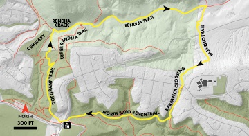
Rendija is the Spanish word for crack, and in this case, it is a reference to a point in Rendija Canyon where the rhyolite walls pinch in to create a narrow passage only a few yards wide. It is an attractive spot—craggy rocks, perpetually shaded, cool in summer, and icy-cold in winter. The best way to explore the crack is using 100-year-old roads. O. O. Grant, called Dot by his family, set up a homestead at the current location of the Guaje Pines Cemetery.
Length: 3.6 miles
Elevation Gain: 300 feet
Fitness Level: Moderate
Features: Interesting canyon, historic roads
Trail Surface: Packed dirt
Mountain Bike Skill Level: Moderate
A road connecting to the Rio Grande Valley led up Rendija Canyon to the site, and then continued along a tributary drainage to reach other homesteads on the mesa top near the present golf course. These roads form the backbone of the trail network today, but as reminders of their origin, visible throughout are ruts from cart traffic gouged in the soft tuff.
Starting from the trailhead, head downhill through the tunnel. On the west side, find the Dot Grant Trail angling to the right. The trail winds among rocks and ponderosa pines before meeting the Upper Rendija Trail. Turn left, drop through a switchback and an S-turn, staying right at two minor junction signs. The trail reaches a sheer wall of rhyolite about a mile from the start. Near the wall, turn right onto the Rendija Trail and pass through the crack. Continue down Rendija Canyon about one mile, passing the Cabra Loop Trail signs, to meet the Pajarito Trail. Turn right and climb eroded switchbacks to reach a parking area. Head straight, cross Rendija Canyon Road and pick up the unmarked Barranca Crossing on the south side of the gravel road. The Crossing begins as an old road ascending the slopes of Barranca Mesa. Cross Barranca Road after the road narrows, then pick up the trail on the other side. Descend to the North Bayo Bench and turn right on the trail of the same name. The trailhead is a little less than a mile away.
