Two bridges over Pueblo Canyon installed in 1999 at the prompting of the Los Alamos Pathways Association make this trip possible.
Length: 3.0 miles
Elevation Gain: 250 feet
Fitness Level: Moderate
Features: Historic trail, deep canyons
Trail Surface: Packed dirt, asphalt
Mountain Bike Skill Level: Challenging
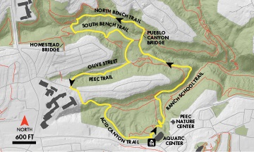
From the trailhead, travel north and make the first right turn. At the top of the cliff, turn right to follow the sharp switchbacks and log stairs of the Ranch School Trail. At the first trail fork, bear left onto the Acid Canyon Trail. Cross a wooden bridge and then come to the larger Acid Canyon Bridge. Turn right, cross the bridge, and then turn right at signpost onto the South Bench Trail. After heading uphill, bear right onto a single-track. After a quarter mile, skirt a large disturbed field, then head toward the canyon and cross on the Pueblo Canyon Bridge.
On the north side of Pueblo Canyon, turn left onto the North Pueblo Bench Trail. This trail winds among the rocks and through three drainages. After about a half mile, turn left onto the Homestead Crossing (there is a signpost about 50 feet down the trail). Cross the Homestead Bridge and immediately turn left to head uphill. In 200 feet, turn left onto the South Pueblo Bench Trail. Follow this trail 0.2 mile to a fork, and then turn left. In a quarter mile, again come to the edge of the large disturbed area. Turn right, then angle right to skirt to the right of what looks like a parking area. In a minute, bear left to walk over a culvert and meet Olive Street. Just across the street, pick up the Pajarito Environmental Education Center (PEEC) Nature Trail and turn right. Follow this trail to its end on Olive Street, turn left onto the road and continue to the Olive Street parking area. Travel through the parking area to Orange Street. Turn left and walk a few yards to 35th Street, turn right and head to the cul-de-sac. Pick up the South Bench Trail at the end of the street and head down into Acid Canyon.
Pass a short bridge to the right and continue straight amid the rocks along the trail. Angle right, cross the bridge, and retrace your steps back to the trailhead.
Download a map & description onto your mobile device: EveryTrail for Bridges Loop