Quemazon Trailhead
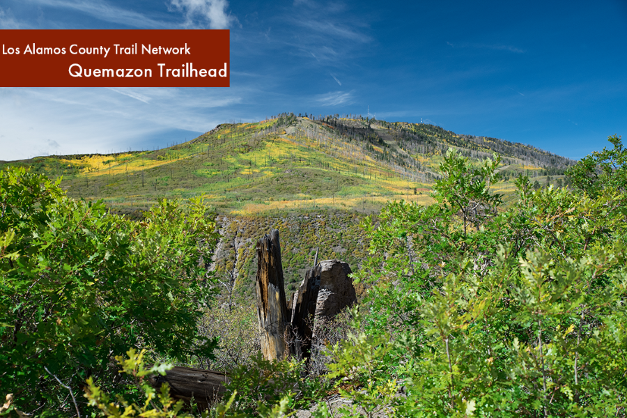
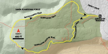
The Quemazon Trailhead is located on the edge of the Western Area neighborhood. It is the launching point for the Quemazon Nature Trail, the Satch Cowan Trail, and further away adventures via the Quemazon Trail. About the first mile of this area is located on Los Alamos County open space and beyond that point is the Santa Fe National Forest.
Finding the Quemazon Trailhead
Finding the Trailhead: From 15th Street and Central Avenue in downtown Los Alamos, head south on 15th. Turn right at the traffic signal at Trinity Drive. Head west to the intersection with Diamond Drive at the Los Alamos Medical Center. Continue straight into the Western Area on Trinity.
In about 0.6 miles, the road begins to swing right and becomes 48th Street. Turn left to stay on Trinity Drive and immediately make another left onto a narrow access road between two houses. The trailhead is a few yards ahead on the right. There is parking for about six vehicles.
Download the Trailhead Info Guide(PDF, 2MB)
Using Los Alamos County Open Space
The Los Alamos County Trail Network is open to non-motorized use only.
Resource Protection
All cultural resources such as Ancestral Pueblo room blocks, pot shards, petroglyphs, and historical artifacts are protected by Federal and State law. Let all cultural resources lie undisturbed.
Share the Trail
These are multi-use trails for pedestrians, equestrians, and bicyclists. Bicyclists should yield to all other users.
Dogs in Los Alamos County Open Space
All dogs must be on a leash when within 100 yards of a trailhead. Dogs must be under voice and sight control at all times.
Safety
When exploring, please stay on marked trails. Always carry water, sunscreen, a hat, extra clothing, a flashlight, and a navigational aid.
Trailhead guides are available at major trailheads, the Los Alamos County Customer Care Center in the Municipal Building, the Los Alamos Chamber of Commerce, and online.
Quemazon Nature Trail
A local favorite, the Quemazon Nature Trail is a 2-mile loop suitable for all hikers. The trail gains about 400 feet in elevation, but the grades are gentle. Trail guides keyed to the number posts along the trail are available at the trailhead or on the trails page of the Los Alamos County web site.
Length: 1.86 miles roundtrip
Elevation Gain: 400 feet
Fitness Level: Moderately easy
Features: Wildfire recovery guide
Trail Surface: Packed dirt, rock
Field Notes: Recommended for foot traffic only
Starting at the trailhead, travel up hill on a wide dirt road, passing the Satch Cowan Trail. In a few minutes, pass to the left of a green gate at a water tank and turn left onto the nature trail. Follow the trail as it winds up the mesa. Continue on the trail as it swings to the north. In a minute, reach the Quemazon Trail, turn right, and return to the trailhead.
Download a map & description onto your mobile device: EveryTrail for Quemazon Nature Trail
Cave of the Winds
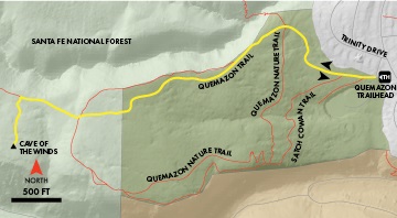
The Cave of the Winds is a small cave that has long been a favorite destination of the kids of Los Alamos. It is reached via the Quemazon Trail and a short spur. Take a flashlight for the cave—it isn’t very big, but it is dark in the back.
Length: 2.2 miles out-and-back
Elevation Gain: 450 feet
Fitness Level: Moderate
Features: Cave
Trail Surface: Packed dirt, rock
Field Notes: Recommended for foot traffic only
Begin at the Quemazon Trailhead near the intersection of 48th and Trinity. Walk up the wide road behind the information kiosk, passing the Satch Cowan Trail to the left. After a few minutes, continue to the left of a water tank and a green gate at the lower intersection with the Quemazon Nature Trail. Steadily climb on the well-worn road for about 0.8 mile. Where the trail finally levels for a bit, meet the upper section of the Quemazon Nature Trail. Continue across a long, flat stretch and watch for the rock cairns that mark the entrance to the Cave of the Winds Trail (this is just after the trail begins climbing again). Turn left and follow the winding trail to the edge of Los Alamos Canyon. The cave is 100 feet below the rim, down a staircase of rock in small notch in the cliff. You have to watch carefully for the entrance to the cave, which is a horizontal slit in the rocks.
Download a map & description onto your mobile device: EveryTrail for Cave of the Winds
Satch Cowan Loop
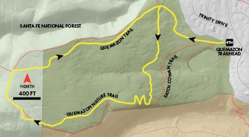
A bit steeper and more rugged than the nature trail, the Satch Cowan Trail hugs the north rim of Los Alamos Canyon to provide spectacular views.
Length: 1.9 miles
Elevation Gain: 400 feet
Fitness Level: Moderate
Features: Views along canyon edge
Trail Surface: Packed dirt, rock
Field Notes: Recommended for foot traffic only
From the Quemazon Trailhead, travel about 200 feet up the wide dirt road behind the information kiosk and bear left onto the Satch Cowan Trail. In a few minutes come to another road. Turn left onto the road and in a few yards; turn right onto the marked trail. Meander uphill on a rocky slope and in 0.2 mile, you will join the Quemazon Nature Trail. Around the first turn to the right, the Satch Cowan Trail bears left and steeply ascends the mesa along the rim of Los Alamos Canyon. Enjoy grand vistas as the trail gains about 200 feet in elevation along the rim. About a mile from the start, rejoin the Nature Trail near marker 27. Turn left onto the Nature Trail as it swings to the north and crosses the main Quemazon Trail. Now heading downhill, enjoy sweeping views. The trail meets the main Quemazon Trail near a water tank. Turn left on the wide trail, pass the water tank, and follow the road back to the trailhead.
Quemazon/Pipeline Loop
This long loop can be hot in summer but makes a great early or late season journey.
Length: 7.8 miles
Elevation Gain: 1,600 feet
Fitness Level: Difficult
Features: 360-degree views
Trail Surface: Packed dirt
Mountain Biking Skill Level: Challenging
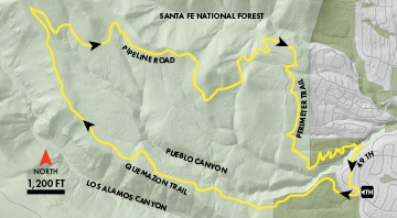
Head up the main Quemazon Trail as it ascends the mesa, gaining 1,500 feet over three miles. At Pipeline Road, turn right and follow its winding route that offers outstanding views of Los Alamos and its surroundings. After about 2.5 miles on the road, turn right onto the Perimeter Trail. The trail winds around several drainages as it traverses above Los Alamos. Near the rim of South Pueblo Canyon, the trail swings to the east, crosses a pipeline, and then wiggles downhill over rocky terrain. After a hairpin turn through a drainage, watch on the right for signs that mark a steep trail that crosses the branch of Pueblo Canyon. On the other side, the trail ascends, turns to the right and passes between two houses on an easement. At the road, head straight on 49th Street. At the t-intersection with Trinity, turn left and in 300 feet, turn right onto the access road for the Quemazon Trailhead.
Download a map & description onto your mobile device: EveryTrail for Quemazon/Pipeline Loop
