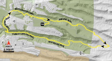
The Bayo/Pueblo Loop offers a long trip within the canyons of Los Alamos. The loop is suitable for all trail users, although the canyon bottoms can be hot at mid-day in summer.
Length: 11 miles
Elevation Gain: 600 feet
Fitness Level: Moderate
Features: Tent rocks, open pine stands
Trail Surface: Packed dirt
Mountain Bike Skill Level: Moderate, some hike-a-bike
From the Kwage Mesa Trailhead, follow the Kwage Mesa Trail to the trail junction near the east side of the white-fenced riding arena. Turn left and in a few yards turn right to parallel the fence to reach the Kwage Mesa Road. At the road, turn left and skirt the north edge of the arena. Pass around a green gate and continue along the north side of the rodeo arena. Watch for a sign pointing to the Bayo Canyon Trail and turn right to head down that trail. After 0.3 miles, turn right onto the main Bayo Canyon Trail. Here the trail follows an old road and in places is worn three feet into the soft rock, making for challenging travel. Near the bottom of the canyon, about 1.6 miles from the start, bear right onto the Fireline Trail. Wind along this trail to its eastern end, cross a dirt road and the sandy channel of Bayo Canyon, and then continue on a sandier trail on the north side of the drainage. The route swings to the east and parallels a fence for about a mile before re-crossing the drainage and meeting the Bayo Canyon Road.
Follow the road to the left, passing several intersections. Just past a concrete low-water crossing, turn right onto the Pueblo Canyon Road. Head up the canyon, making two wet stream crossings. After two dry crossings, about 1.8 miles from the Bayo Canyon Road, turn left onto the winding Tent Rocks Trail. Follow this trail as it climbs for 1.7 miles up the canyon before again rejoining the Pueblo Canyon Road.
Turn left and continue on the road for about 2 miles to meet the East Fork Trail. Turn right onto this trail and climb steeply on a twisting track. After crossing a short bridge (not suitable for horses), turn right onto a road, climb a hill, then in 0.1-mile bear right to rejoin the East Fork Trail. (To avoid the stairs ahead, equestrians should (and mountain bike riders may want to) stay on the road and rejoin the East Fork Trail in a half-mile via the Walnut Canyon Rim Trail.) Descend to the canyon bottom; head upstream amid huge pines, then climb wooden stairs to reach the mesa top. Pass the Walnut Canyon Rim Trail on the right and follow the trail to its end at San Ildefonso Road.
Carefully cross San Ildefonso to the sidewalk on the east side. Turn left and cross North Mesa Road at the San Ildefonso roundabout. Pass a culvert tunnel on the left, bear right across a disturbed area, and pick up the Bayo Canyon Trail to the right. Follow this trail 1.1 miles to the access trail leading back to the trailhead at the stables.
